Fall in love with the Lake District
Our #CulturalConcierge loves the Lake District as much as we do and has come up with a non-drive bus...


by Rob Hayes / Windermere
Staying in Windermere for your next staycation and plan on spending most of your time in the great outdoors? If so, then we’d highly recommend embarking on one of these brilliant walking trails during your stay!
From light and leisurely walks to some of the most challenging trails in the region, we’ve put together a comprehensive guide covering all the best walks in Windermere that’ll give you the chance to experience the natural beauty that this national park is famous for.
Keep scrolling to uncover all the best walks from Windermere…
Difficulty: Easy
Length: 5km
Avg. Time: 1 hour 20 mins
Elevation (gain): 149m
Arguably the best introductory walk for newcomers to Windermere, this route takes walkers from the train station, through the heart of the town and along the banks of England’s largest lake.
After parking up at the station car park, begin this Windermere walk by heading out of the car park and onto Victoria Street, where you’ll see our lovely office right ahead of you! Here, you’ll need to cross the road and take a left around the bend onto the High Street, which you’ll continue along for a couple of minutes before reaching the junction.
At the junction, take a right onto Elleray Road before taking the next left onto Ambleside Road (A591). Once you reach St Mary’s Church, go past the junction with St Mary’s Park and take the footpath on your left just before the entrance to Cedar Manor.
From here, simply follow the footpath until you reach the junction with Rayrigg Road. Here, cross over and continue along the footpath towards the banks of Lake Windermere.
Once you reach the lake, the path will curve to the left at Millerground and take you along the edge of the lake and around the foot of Queen Adelaide’s Hill, where you’ll get to take in the unforgettable views of the fells across the water.
Once you reach the junction in the path, take a left and follow the route back to Rayrigg Road (A592). When you reach the road, take a right and follow it south towards the Windermere Jetty Museum (1). Then, just after you pass the museum, take a left turning onto Millbeckstock before crossing over Longlands Road to follow the Sheriff’s Walk path ahead of you.
Following Sheriff’s Walk, you’ll eventually reach the junction with Lake Road (A5074), where you’ll take a left and follow the road north, taking you back through the town centre and past the Baddeley Clock (3).
Eventually, once you reach the fork in the road, take the left turning onto Main Road, the second right onto Victoria Street and a final right turn onto the path back to the car park where you began.
Difficulty: Easy
Length: 9km
Avg. Time: 2 hours 25 mins
Elevation (gain): 239m
Taking walkers from the Windermere Quays around the picturesque Heathwaite Hill, the Bowness-on-Windermere Circular is one of the easier Windermere walks that’s best experienced on a sunny day.
After parking up at Glebe Road car park, begin by heading north back towards the town along Lake Road. Once you reach the roundabout, take the road on the right (Crag Brow, A5074) before taking another right onto Helm Road.
Making your way down Helm Road, you’ll eventually come to a junction where you’ll find a turn off to your left (Biskey Howe Road) and a lovely waterfall to stop off at (1).
At the end of Helm Road, you’ll come across a split in the road – Here, take a right and follow the path through the field. Continuing the route in a clockwise direction, you’ll pass around the back of Heathwaite Hill before reaching Post Knott (2), known for being a scenic hotspot offer fantastic views over Lake Windermere.
Following the Dales Way route from Post Knott, you’ll eventually come out onto Brantfell Road, which you’ll follow back to the town, crossing over at the junction onto St Martins Hill and taking a left onto Lake Road.
Once you’ve reached Lake Road, simply continue following the road southward back towards the quays where you began.
Difficulty: Moderate
Length: 4.2km
Avg. Time: 1 hour 10 mins
Elevation (gain): 126m
Moving onto the longer and more challenging Windermere walks, the Windermere Town & Lake Circular is a fantastic route to consider taking, especially if you’re visiting the area for the first time!
Starting at the train station car park, you’ll begin by heading westward down Ambleside Road (A591) towards the heart of the town.
Once you pass St Mary’s Church on your left, go past the next turning onto St Mary’s Park and head down the footpath on the left, which can be found just next to the entrance of Cedar Manor.
After exiting the path onto Rayrigg Road (A592), take a left, cross over and take a right through the gate onto the next footpath.
Arguably the most picturesque part of this Windermere walk, following the path in a counterclockwise direction will bring you through an enchanting woodland, with the lovely Wansdale Beck passing alongside the pathway.
Once you reach the lakeside, the path will take you southward along the banks, taking you around the foot of Queen Adelaide’s Hill before bringing you back out onto Rayrigg Road. When you do, take a left and start heading northward before taking the next right onto Birthwaite Road.
Heading up the road, you’ll eventually come across the entrance to a footpath on your left that’s marked with a signpost – Head down this path, which will bring you out onto Old College Lane, where you’ll take a left, following the road back up to St Mary’s Church.
To complete this Windermere walk, simply take a right onto Ambleside Road and continue eastward back the way you came to the station car park.
Difficulty: Moderate
Length: 8.5km
Avg. Time: 2 hours 20 mins
Elevation (gain): 222m
Also a moderately-challenging Windermere walk is the Biskey Howe, Cleabarrow, Brant Fell & Post Knott Circular, taking trekkers around some of the area’s most iconic hills.
To begin, start by parking up at the Rayrigg Road car park in the heart of the town.
From there, head right out of the car park onto Rayrigg Road and take the left at the end of the road onto Crag Brow, before taking the second right onto Helm Road.
Following the road for around half a kilometre, you’ll have the opportunity to veer off to the left and take in the view from Biskey Howe.
Rejoining Helm Road, simply follow it to the fork in the road and take a right. Following the path through the field, you’ll eventually come out at Lickbarrow Road, where you’ll need to cross the road and carry on along the path eastward.
Once you’ve reached the cycle track, take a right and follow the path southwards, taking you past the foot of Heathwaite Hill down towards the B5284, where you’ll take a right before joining the next path on the right towards Post Knott.
To finish, simply follow the path before turning onto Brantfell Road, which you’ll follow back into the town where you started.
It’s important to note that this route includes a lot of unpaved paths and steep sections, so we’d highly recommend packing suitable walking boots/equipment for this Windermere walk, especially if the ground is wet or icy.
Difficulty: Hard
Length: 14.3km
Avg. Time: 4 hours 40 mins
Elevation (gain): 590m
If you’re planning on spending a full afternoon in the great outdoors, then taking the wonderful Windermere to Ambleside route is a fantastic idea to consider.
Starting at Windermere railway station, exit the car park onto Church Street (A591) and head up onto the layby the right, taking the path on the left that’s signposted with trail maps.
Following the route northwards, this pathway will take you up and around Orrest Head and past Wynlass Beck.
Following the next pathway ahead of you, you’ll continue northwards past Highlands Wood and towards Moorhowe Road. When you exit onto the road, take a right, cross over and take the next left onto Longmire Road.
Heading past The Howe, you’ll eventually come out at the village of Troutbeck, which you’ll past through before hopping onto Nanny Lane towards Ambleside.
Here, you’ll make the relatively steep ascent up towards Wanfell and pass over the top of the hill before descending towards a Lake District hidden gem waterfall, Stock Ghyll Force, on the outskirts of Ambleside.
To finish up, we’d highly recommend stopping off at one of the town’s many fantastic pubs, cafés or restaurants for a well-deserved drink and a bite to eat. Then, you can either follow the same route back or hop on the ferry back to Windermere.
Difficulty: Hard
Length: 46km
Avg. Time: 12 hours 30 mins
Elevation (gain): 1275m
Taking walkers around England’s largest lake, this challenging walk is a fantastic route that’s best enjoyed on a clear and dry day. Due to the estimated completion time for this Windermere walk, it might be worth setting aside a couple of days for this route.
To begin, start by parking up at Glebe Road car park, which can be found just opposite The Ship Inn next to the Windermere Quays. Exiting the car park onto Glebe Road, take a right and continue around the corner past the visitor centre and onto the Promenade, where you’ll take a left.
From here, continue northwards up to Royal Square before taking a right onto Crag Brow and the next immediate right onto Helm Road. At the top of the road, you’ll arrive at Biskey Howe, a where you’ll get to take in the stunning views of Bowness and Lake Windermere.
When you’re ready to continue, carry on following Helm Road before taking a right onto the footpath before the cut-through to Annisgarth Avenue. After passing through the wooded area and along the edge of the open fields you’ll arrive at the junction with Lickbarrow Road. If you look right, you’ll see a signpost on the opposite side of the road, where you’ll need to hop over the stone wall or through the red gate and continue through the fields.
Once you’re out of the fields and reach the junction with the paved footpath, take a right and continue along the trail (Dales Way) until you reach the junction with the main road, where you’ll make a right turn.
Staying on the right hand side of the road, continue for a few minutes until you see a turn-off to the right, marked with a large blue sign for “Low Cleabarrow”. Turn up this road and continue onto the Dales Way before reaching the junction with Lickbarrow Road. At the junction, simply cross over and pass through the next gate, following the footpath that runs alongside the fenced-off field to the right.
From here, you can either continue all the way along the Dales Way, bringing you back to the town at Brantfell Road. Alternatively, if you’ve got the time, you can follow the route southwards around Brant Fell and Post Knott (5) before reaching Brantfell Road.
From here, simply follow the road back into the town, which will eventually bring you to the junction with Lake Road. Here, take a final left and head back along the Promenade to the pub and car park where you started.
This is the perfect route for experiencing the full beauty of the Lake, and if you’re lucky, you might even see the famous Bownessie along the way!
Find plenty more places to enjoy the best of the region’s countryside with this guide covering the best walks in the Lake District, along with our best walks from Keswick guide. Alternatively, if you’re feeling adventurous, why not take a look at the best wild swimming hotspots in the Lake District with our handy guide?
Discover this selection of cottages in Windermere for the ideal place to stay during your next visit.
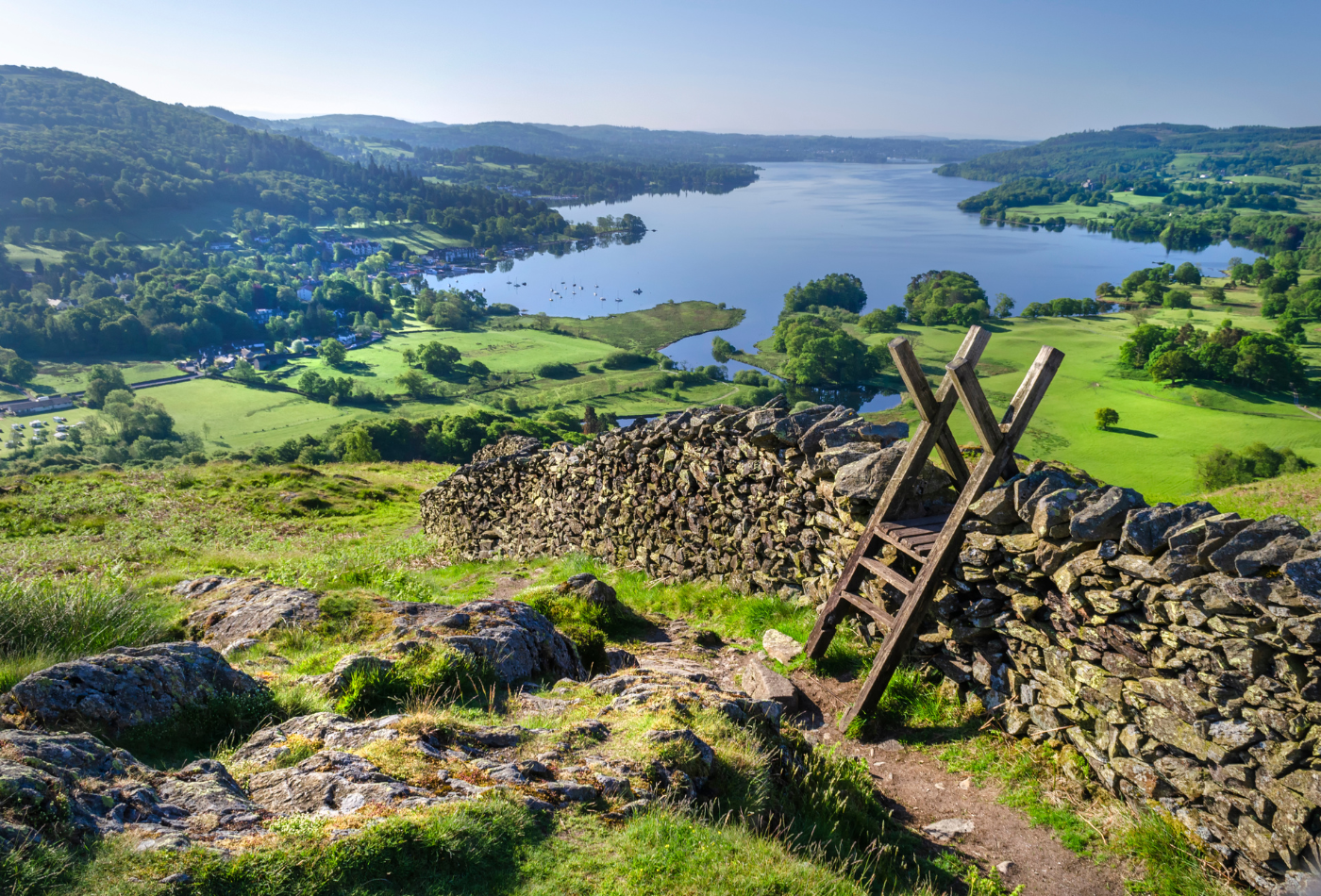
Image credit: Garry Basnett – Lake Windermere from Todd Crag
by Rob Hayes / Windermere

I'm Rob and I joined the Sykes team in February 2024. I am a passionate writer and have always enjoyed holidays in the UK, especia...
Read More About AuthorSign up to receive exclusive offers, competitions and the latest news to your inbox, and you'll be entered into our monthly prize-draw 3 times!
Our #CulturalConcierge loves the Lake District as much as we do and has come up with a non-drive bus...
Cumbria is always normally full of amazing events, festivals, music and art, but we know 2021 maybe a little...

