Favourite Spring Walks
Spring walks in the Lakes are high up on our to-do list. Finally waking up from winter slumbers, the...

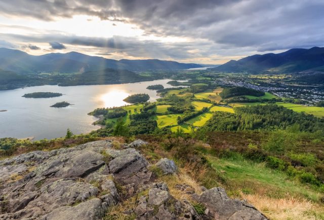


Surrounded by crags and fells on all sides and situated right on the edge of Derwentwater, there’s no shortage of fantastic walks in Keswick for you to embark on during your next visit here!
Whether you’re an experienced hiker looking for your next challenge, or you’re simply looking for a way to enjoy the great outdoors whilst taking in the beautiful views of the region, this guide will be sure to help you out. Starting out with the shortest routes and gradually increasing in difficulty, these moderately difficult Keswick walks make for the ultimate way to enjoy the Lake District’s natural beauty.
*We recommend purchasing an OS map, or similar walking maps with descriptions from the Moot Hall Tourist Information Centre before heading out. Stay safe in the mountains!
Keep scrolling to discover 5 of the best walks in and around Keswick…
Difficulty: Moderate
Length: 5.5km
Avg. Time: 2 hrs
Elevation (gain): 305m
Offering fantastic views of the lake from the summit, the Walla Crag Circular is one of the more easy walks in Keswick, taking visitors an average of around two hours to complete from start to finish. To begin, start by parking up at the Great Wood Car Park at the foot of the crag and just off the B5289. It’s important to note that it’s owned and operated by the National Trust, so parking is free for those of you with memberships.
When you’re ready to set off, start by hopping onto the Walla Crag Trail through the wooded area. Continue along the trail for around half a kilometre, before bearing left at the junction in the footpath.
For the next kilometre or so, you’ll wrap around the southern end of the crag in a counterclockwise direction. At the next junction in the path, simply continue northwards for around 0.2 kilometres to the top of Walla Crag, where you’ll get to witness breathtaking views of the lake on a clear day.
On the returning journey, head back down the path you came from, taking the path to the left at the junction. From here, you’ll continue your descent for around two kilometres before reaching the Ashness Bridge. Once here, simply continue along the path northwards for around 1.8 kilometres, before finally reaching the Great Wood Car Park where you began.
Difficulty: Moderate
Length: 7.1km
Avg. Time: 2 hrs 30 mins
Elevation (gain): 398m
Taking in the iconic Catbells on the western side of Derwentwater, the Hawes End, Catbells and Derwent Circular is one of the more popular walks in Keswick, despite its relatively challenging elevation gain. Best experienced on a dry day, this moderately difficult route is well worth the journey, taking around two-and-a-half hours to complete.
There is limited layby parking at the start of this walk at Hawes end, so we recommend arriving early. You’ll begin by taking the path and steps to the left, the kilometre-long ascent begins straight away, taking you to the top of the first top of Skellgill Bank.
From here, you’ll continue along the top of the ridge southwards for around one kilometre before reaching the second summit of Catbells. Then, simply continue following the footpath down to the col, from here take the left path down steep stone steps towards the lake and road for another two kilometres in a counter clockwise direction, taking you around the southern end of the crag.
After making the descent, you’ll reach a small car park at the end of the path. Here, you’ll see a signpost on the other side of the road pointing right, which you’ll follow down to the High Brandelhow Jetty on the banks of the lake. From here, you’ll follow the lakeside footpath for another kilometre before reaching the Low Brandelhow Jetty.
At the northern jetty, bear left on the footpath and continue westwards until you reach the main road. From here, take a left and follow the road southwards for another few minutes before finally reaching Cat Bells Car Park, where you began.
Difficulty: Moderate
Length: 8.2km
Avg. Time: 2 hrs 40 mins
Elevation (gain): 345m
The Keswick and Walla Crag circular is a brilliant Keswick walking route that’ll take you right past the edge of the lake before taking you up Walla Crag, where you’ll get to take in the stunning views of Derwentwater and the surrounding landscape.
After parking up in Central Car Park in the heart of the town, exit onto Lake Road Court and take a left onto Heads Road (B5289) and the next right, where you’ll spot the Hope Café. Here, hop onto the footpath, continuing through Hope Park before hopping onto Lake Road. From here, simply follow the road southward for around half a kilometre towards the end of the road, where you’ll hop onto another footpath.
Once you’re on the path, you’ll continue for around a kilometre, passing by the Ruskin Monument along the eastern edge of Derwentwater before reaching a small junction, where you’ll turn right and follow the route past the Hundred Year Stone sculpture and a small pebble beach at Calfclose Bay.
After passing the beach, you’ll arrive at the junction with the B5289, where you’ll cross over and join the footpath on the other side of the road, known as the Walla Crag Trail. Here, take a right and follow the path in a counterclockwise direction for around 1.2 kilometres, which will bring you to the top of Walla Crag and the halfway point on this Keswick walking route.
When you’re ready to continue, carry on northwards along the ridge for around 1.5 kilometres before reaching the end of the Walla Crag Trail and taking a left onto the adjoining footpath.
Difficulty: Easy/Moderate
Length: 9.2km
Avg. Time: 2 hrs 45 mins
Elevation (gain): 336m
Arguably one of the most popular walks around Keswick is the Latrigg Fell walk, a relatively easy route that offers impeccable views of the town and nearby Derwentwater from the summit.
To begin, start by parking up at the Keswick Car Park next to the leisure centre. From here, make your way out of the car park, turn left at the roundabout onto Brundholme Road and continue northwards. Continue along the road for around half a kilometre before reaching the junction with Spoonygreen Lane, where you’ll turn right and make the ascent towards Latrigg Fell.
At the end of Spoonygreen Lane, around 1km from the junction, continue onto the footpath that passes through the woodland before taking the sharp right turn towards the summit. Continuing for around a kilometre, you’ll eventually reach the top of the fell, where you’ll get to take in the unforgettable views of the town and lake.
From the summit, start making your way eastwards for around 2 kilometres before reaching the footpath. From here, simply continue along the path, passing over the River Greta and through the woodlands before passing beneath the Keswick Bypass. At the junction with Penrith Road, simply cross over and continue following the path, which will take you over a final footbridge across the river before bringing you back to the car park where you started.
Difficulty: Moderate
Length: 15.3km
Avg. Time: 3 hrs 40 mins
Elevation (gain): 280m
The longest and most challenging walk near Keswick, the Derwentwater Circular, takes nearly four hours to complete and is recommended for walkers with a good level of experience.
Starting off at the Lakeside Car Park next to the Theatre by the Lake, you’ll begin this Keswick walk by exiting the car park and heading southwards along Lake Road before hopping onto the footpath at the dead-end, which is around half a kilometre from the car park.
From here, the route towards the southern end of the lake is pretty simple and easy to follow, taking you past landmarks like the Ruskin Monument, the Centenary Stone and Barrow Bay Jetty before reaching the Kettlewell Car Park.
At the car park, hop back onto the side of the B5289 and continue southwards for around a kilometre before turning right onto a footpath just after the Lodore Falls Hotel, which you’ll pass on your left.
Once you’re on the path, cross over the River Derwent Foot Bridge and continue westwards along the southern banks of the lake and around to the western side, travelling in a clockwise direction for around two kilometres before reaching High Brandelhow Jetty. From here, simply continue northwards along the banks of the lake for around a kilometre before reaching Low Brandelhow Jetty.
After passing the jetty, follow the path veering off to the left and start heading through Overside Wood towards the Nichol End Jetty, where you’ll turn right onto the Regional Route 71 and follow the road northwards to the village of Portinscale. When you reach the bend in the road in the village, take a right and continue along the route, passing over the river as you go. Then, as you pass the layby to your left, you’ll see the entrance to a footpath on your right marked as the Cumbria Way, which you’ll hop onto and continue through a field.
From here, simply follow the path all the way to the junction at the River Greta, where you’ll turn left onto High Hill, before turning right and crossing over the river back into Keswick. From here, simply continue along Main Street through the heart of the town before bearing right and rejoining Lake Road. From here, continue southwards along the road before reaching the car park where you began this Keswick walk.
Inspired to visit? Book your next holiday in Keswick today – one thing’s for sure, you’ll never be short of things to do!
If you’re searching for even more magical hikes in the region, then this comprehensive guide covering the best walks in the Lake District is a must-read, much like our list of our favourite Spring walks and these fantastic Windermere walks. Alternatively, for those of you looking for a greater challenge, be sure to check out these 7 Lake District mountains that are worth the hike and for those wishing for slow paced walks with pretty waterfalls, make sure to browse this Lake District Hidden Gem Waterfalls Guide.

I'm Rob and I joined the Sykes team in February 2024. I am a passionate writer and have always enjoyed holidays in the UK, especia...
Read More About AuthorSign up to receive exclusive offers, competitions and the latest news to your inbox, and you'll be entered into our monthly prize-draw 3 times!
Spring walks in the Lakes are high up on our to-do list. Finally waking up from winter slumbers, the...
Made up of four summits, the Langdale Pikes are one of the Lake Districts more famous walking rounds. Sitting...
Renowned as the tallest mountain in England, Scafell Pike is one of the country’s most iconic natural landscapes, attracting...

